
Blog
stories • happenings • adventures
Blog
stories • happenings • adventures
Planning for Extreme Weather Events: Part 1

This post is a special guest post written by Luc Mehl, a fellow Alaskan and a leader in the field of trip planning and preparation.
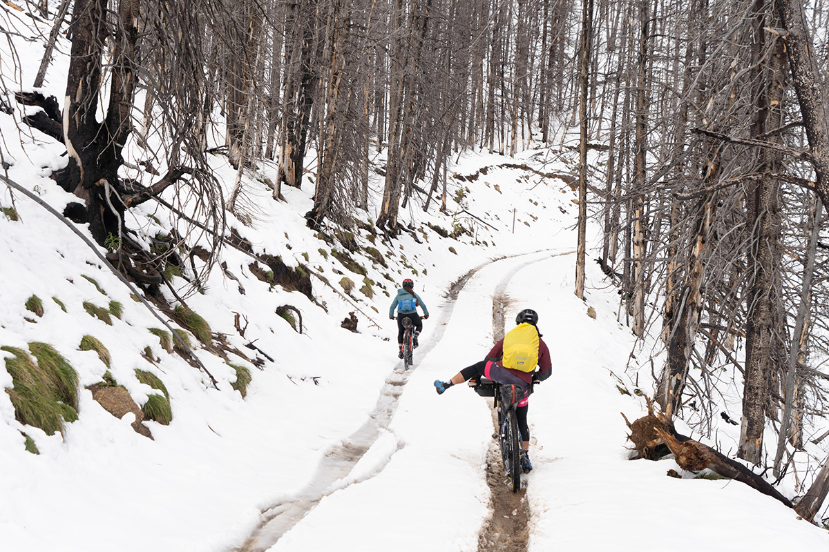
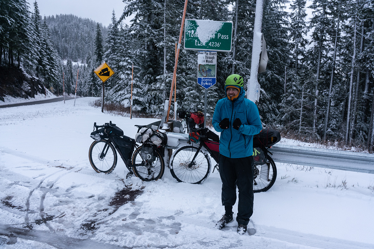
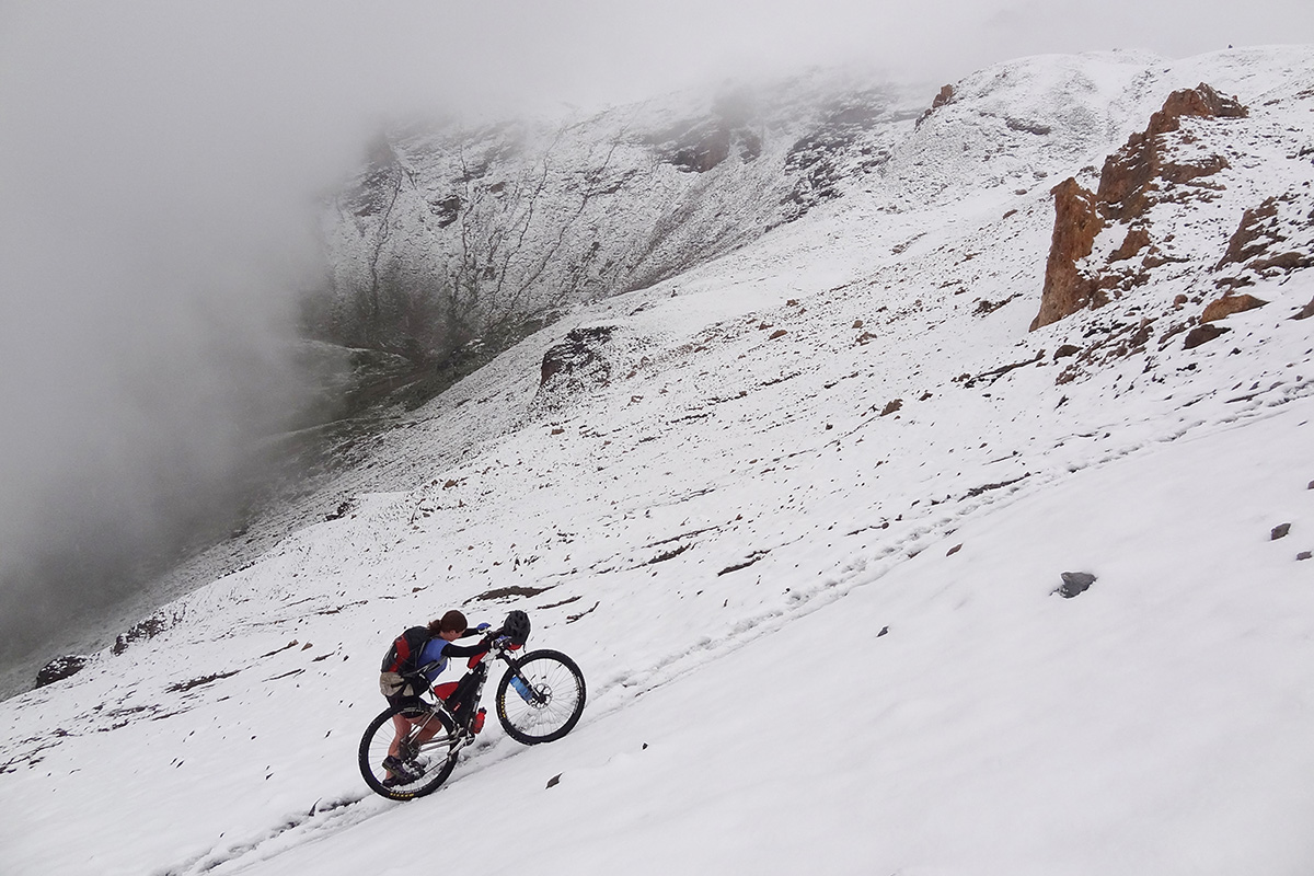
Modern advances in manufacturing and technology allow us to travel farther from home than ever before. But being far from home often means being far from help. Understandably, trip preparation often focuses on what we can control, such as the bike, accessories, food and nutrition—and with that comes a sense of being prepared for what nature throws at us. But preparation should include contingency plans for factors that we can’t control, such as rapidly changing weather. The added exposure and vulnerability of biking in remote settings was asserted during the 2022 Tour Divide Race, when fifteen riders were evacuated and treated for exposure to unanticipated winter conditions. Despite these injuries, it could have been worse. Runners in the 2021 Baiyin ultramarathon (China) were not so lucky—twenty-one participants died due to exposure to severe weather during the race.
As ‘outlier’ weather events become more common due to the changing climate, honing our forecasting skills can help us anticipate dangerous weather and recognize when it is time to turn around. Weather is a hazard—something we can’t control and that can cause harm—but the good news is, we are better positioned than ever to anticipate changing weather.
In this article, we review several free digital forecasting tools that can help us plan and complete our outings. These resources have been heavily tested during four-season adventuring in remote Alaska. This is advanced trip planning content that will elevate your game in making smart choices both before and during a big outing. If the learning curve feels steep, start with exploring the Windy.com app, introduced in Part 2 of this series.
Part 1 of this series presents near-real-time satellite imagery, which allows you to gauge surface conditions days and even hours ago. Part 2 will present advanced weather forecasting tools both at home and while on route.
Near-real-time satellite imagery
Our most powerful planning tools are at home, where a computer and internet connection provide access to satellite imagery. Applications such as Google Earth and Esri provide high-resolution images that allow you to pickout roads, trails, and bridges. But these applications provide the ‘best’ cloud-free image, which might have been captured last month or last decade. These applications are great for mapping, but not much help at determining current conditions.
“Near-real-time” refers to images from satellites in fixed orbits. Images are not as high-resolution as what we see in Google Earth, but they can be hours or days old, providing a better sense of current conditions. In general, more frequent captures come in with lower resolution. Three sources are particularly helpful for trip planning: NASA MODIS, Landsat 8-9, and Sentinel 2 L2A.
Near-real-time imagery is particularly useful when trying to determine seasonal fluctuations, such as:
- How much snow is in the mountains
- The elevation of the snow line
- Whether vegetation has started to leaf out in the spring
- If wildfires and smoke are affecting the area
- Etc.
As a demonstration, we’ll examine near-real-time images captured near the 2022 Tour Divide evacuations, with particular attention to snow.
NASA’s MODIS satellites collect two images per day. These images are typically 250-m resolution—good enough to understand general conditions, but not good enough for detailed evaluation. The Worldview application features an intuitive time filter that allows us to compare current conditions with previous months and years. Toggle between the Aqua and Terra satellites in the left-hand control panel to identify the sharpest image in the area of interest.
The image below captures the Fernie, BC, region of the Tour Divide a week after participants were rescued in the area. The imagery is grainy, but you can see the snowy peaks south and east of Fernie.
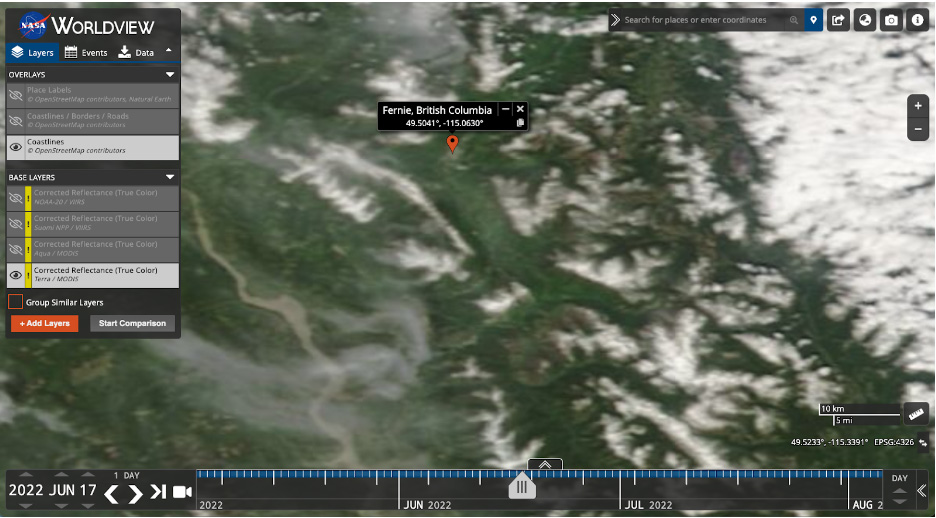
Photo: The Fernie, BC, region as captured by the MODIS Terra satellite, June 17, 2022, a week after the Tour Divide rescues. It can be difficult to distinguish cloud cover (upper right corner) from snow (ridge and mountain tops). Toggling forward and back on the calendar helps with this distinction.
It would be helpful to overlay a GPS track over the imagery, but this isn’t possible with the Worldview application. Advanced users can export georeferenced images from Worldview and view them on Google Earth, along with GPS tracks. Select the camera icon from the upper left, maximize the resolution, and choose KMZ for the format. The produced KMZ file can then be opened in Google Earth for viewing with a route line overlay.
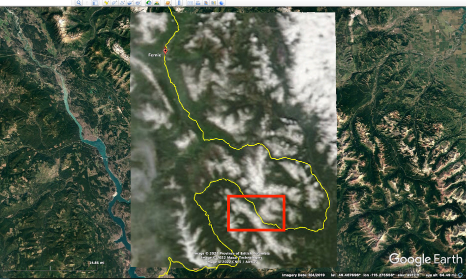
Photo: NASA Worldview imagery (June 17, 2022) as seen when imported into Google Earth. The Fernie, BC, region of the Tour Divide trail is shown in yellow. Note the snow encroaching at the pass between Mt. Doupe and Inverted Peak (red outline). This region is featured in the following images. Note that this location is used for demonstration purposes but is not the location of the Tour Divide rescues.
Landsat 8-9 via Sentinel PlaygroundThe Landsat 8-9 satellites provide higher resolution imagery than the MODIS satellites (30m), but less frequently—typically two or three times per week. Sentinel Playground provides easy access to explore Landsat imagery. Start by deselecting all satellites with the satellite icon in the upper left corner so that you can use the search box and basemap to get your bearings. Then choose Landsat 8-9 from the satellite list.
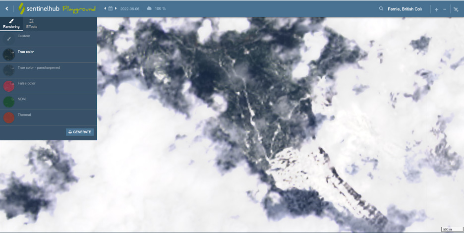 Photo: The Mt. Doupe and Inverted Peak region, as seen in Landsat 8-9 imagery from June 6th, 2022, four days before the Tour Divide rescues.
Sentinel 2 L2A via Sentinel PlaygroundSentinel 2 imagery is considerably higher resolution than Landsat 8-9 and MODIS (10m). As you might expect, it is available less frequently. Sentinel Playgound is the easiest way to view Sentinel 2 L2A imagery—simply change the satellite selection from the satellite icon in the upper right.
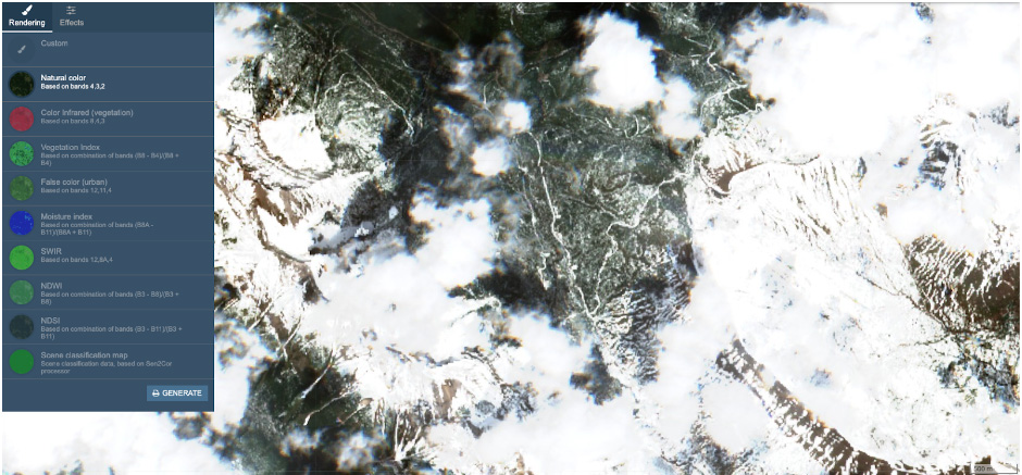 Photo:
The highest resolution near-real-time satellite imagery available for the Mt. Doupe and Inverted Peak region, June 10th, 2022. Note that snow is clearly visible on the roads.
Google Earth super users can view Landsat and Sentinel images along with GPS tracks by downloading images using the EO Browser application. EO Browser is closely related to Sentinel Playground, but the site is less-intuitive. To generate georeferenced images in EO Browser, create an account and select the ‘Download image’ from the toolbar at right. Choose ‘Analytical’ from the download options. The downloaded file can be opened in Google Earth or other geospatial applications.
Alternatively, GPS tracks can be viewed with satellite imagery with the EOS Landviewer application. The free subscription level of EOS Landviewer limits users to 10 images per day, but this is typically adequate. Select the ‘My AOI’ square icon from the toolbar at right to upload a GPX or KML file.

Photo: A Tour Divide GPS track imported into EOS Landviewer, with Sentinel 2 L2A imagery from the Mt. Doupe and Inverted Peak region, June 10th, 2022.
Near-real-time satellite imagery is best at helping you determine the surface conditions within the past days and weeks. But we also want to know what to expect in the days and weeks during our outings. We’ll examine weather forecasting tools in Part 2 of this series. Stay tuned!
About Luc Mehl
Luc Mehl is an outdoor educator in Anchorage, Alaska. Luc has traveled over 10,000 miles of remote Alaska by foot, ski, paddle, pedal, and ice skate. The author of award-winning The Packraft Handbook, Luc and teaches swiftwater rescue, packrafting, trip-planning, and ice rescue. Luc’s trip reports, inspiration and planning resources are available at https://thingstolucat.com/. Check out his new online module based skill building course Start and End at Home at https://courses.thingstolucat.com/start-and-end-at-home.