
Blog
stories • happenings • adventures
Blog
stories • happenings • adventures
Planning for Extreme Weather Events: Part 2
This post is a special guest post written by Luc Mehl, a fellow Alaskan and a leader in the field of trip planning and preparation.
Part 1 of this series presented near-real-time satellite imagery applications that help us determine surface conditions days or weeks ago. We used imagery from the Fernie, BC, area around June 10th, when Tour Divide cyclists were evacuated due to winter conditions along the trails.
Near-real-time imagery can be very helpful in determining seasonal conditions such as snow and smoke extent, but it doesn’t provide a forecast of what to expect. We’ll turn to weather forecasting applications to help anticipate extreme conditions. The availability of tools depends on your setting (internet access), so we’ll break this discussion into three settings:
• Planning at home
• En route and with cellular coverage
• En route without cellular coverage
Weather Applications
After using near-real-time satellite imagery to make a best guess at current conditions, our next objective is to determine the weather forecast. While point forecasts are just a few clicks away on our smartphones, what we are really after is a forecast along the route—like an elevation profile but with weather data instead of elevation.
Planning at Home
As discussed in Part 1, the best place to do computing is at home with fast access to real-time weather observations, imagery, and modeling. This ‘know before you go’ strategy can prevent a small mishap from turning into a big problem. And it can be fun—exploring a region on the computer before and after a trip makes you more familiar with the region, adding another layer to your experience.
Mapping Applications
Most mapping applications now include weather layers. CalTopo provides a 2-day forecast and longer point forecasts by clicking anywhere on the map (continental US only). Gaia GPS provides a 3-day forecast with a slightly larger regional extent.
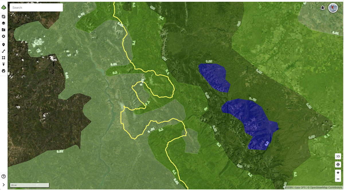
Photo: A Tour Divide GPS track near Fernie, BC, and 3-day NOAA precipitation forecast as viewed with Gaia GPS.
Windy.com
Given the temporal and geographical limitations of CalTopo and Gaia GPS, I prefer to work with Windy.com. Windy provides an 11-day forecast and is incredibly well-designed: from eye candy to deep analysis, Windy can match your level of interest. And it’s free!
For short excursions, Windy will likely meet your needs by simply clicking on the map to view point forecasts. Compare forecast visualizations and various models by clicking on tabs at the bottom of the screen. I prefer the ‘meteogram’ view, which provides an intuitive visualization of cloud density, elevation, and precipitation quantities.
For longer trips, consider uploading the GPS track directly into Windy. Open the menu (hamburger icon) in the upper left and select ‘Upload, display and share your KML, GPX or GeoJSON.’ You can even share your uploaded route with trip partners or in-town contact (the role of the in-town contact is discussed below) via a custom URL.
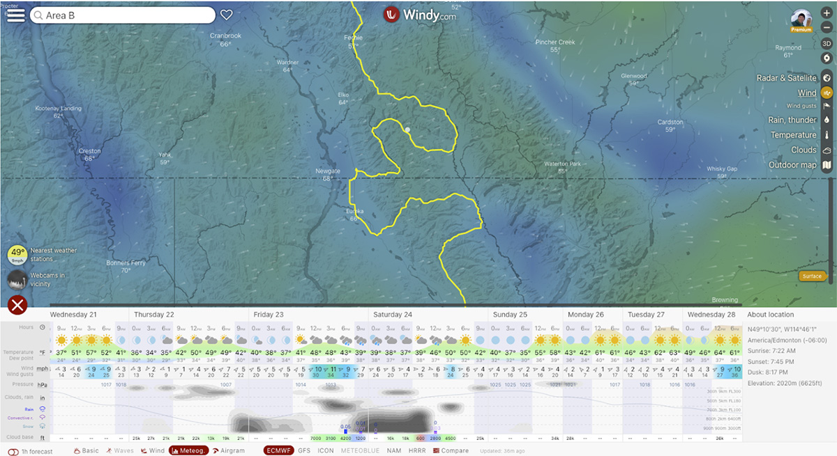
Photo: A meteogram weather forecast along the Tour Divide trail, as seen on Windy.com.
En Route with Cellular Coverage
Being on the trail means we will have lost some of our computing power—but that is kind of the point, right? By doing the heavy lifting ahead of time, our days in the woods can be a more immersive experience—more green time, and less screen time.
Windy smartphone app
If the exposure of our route warrants monitoring weather conditions, and we have a moderately strong cellular signal, the windy app is the forecasting tool of choice. We can’t view a GPS track on the app, but select “Find my location” from the menu (hamburger icon) to generate an 11-day point forecast at your location. You can choose for the high-zoom basemap to be a map or satellite imagery under “Settings” (hamburger icon).
The windy app even allows us to designate alerts in the area of interest: define parameters such as wind speed, precipitation, duration, etc., to be sent via text message or email. To create an alert, click the point of interest and expand the forecast view. Select the heart icon in the upper right and then select ‘Alert for this spot.’
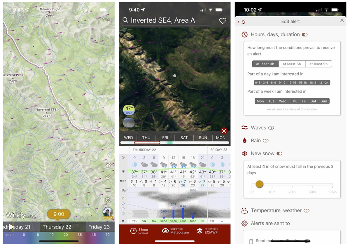
Photos: The windy app, as viewed on an iPhone. Left: A terrain basemap in the Mount Doupe and Inverted Peak region of British Columbia. Center: A meteogram forecast and satellite image basemap. Right: Creating a weather alert for specific conditions.
Designating an In-Town Contact
If we are actively seeking to avoid screen time, or have weak cellular coverage, it is very helpful to have an in-town contact doing the weather work for us. An in-town contact is someone that knows the trip plan, has been provided with an action plan in case we are overdue, and can serve as our point of contact during the trip. If you are sending location updates (via cell phone or satellite messenger), the in-town contact can view your location in Windy using the route URL that you created, and send updates if conditions are degrading. Text messages can be sent and received with weaker cellular signals than voice messaging and apps.
En Route without Cellular Coverage
If our adventure takes us outside of the cellular network, our forecasting tools are limited to satellite messengers and our own forecasting abilities (Jim Woodmencey’s Mountain Weather course has an excellent reputation). The role of the in-town contact is the same as outlined above, but they should be prepared to spend more time monitoring conditions if we are traveling in remote areas.
Satellite Emergency Notification Devices
Two-way satellite messengers (e.g., SPOT, inReach, Zoleo) commonly include weather forecasting abilities. Services vary from device to device, so do some trial runs before heading into the woods.
wx2inreach
Martin le Roux, a software developer in Colorado, has created a custom, more advanced, weather tool for the inReach. Martin’s “wx2inreach” service allows you to schedule daily weather forecasts, select weather providers, and even request forecasts for specific mountains and elevations. This service is free (consider donating to Martin for service maintenance), but messaging fees still apply.
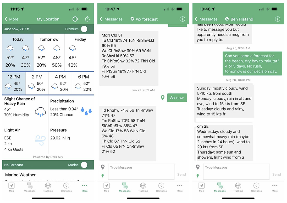
Point forecasts available via the Garmin inReach, as viewed in the Earthmate app on an iPhone. Left: A Dark Sky forecast. Center: A wx2inreach forecast. Right: A forecast from an in-town contact.
Digging Deeper
The past two years have been witness to a disturbing number of near-misses, injuries, and fatalities due to unexpected weather: winter conditions in the Baiyin ultramarathon and Tour Divide, hikers caught by extreme heat in the southwest US, and kayakers paddling high waters in the Rocky Mountains. Outdoor time might be deeply fulfilling, but it is also supposed to be fun. And it is definitely supposed to end with sharing stories with friends and family back home.
Parts 1 and 2 of this series introduce a suite of free or inexpensive applications that can help you prepare for outings. Near-real-time imagery provides a glimpse of recent conditions, and weather applications such as windy.com help you know what is coming. Front-loading this work allows you to spend more time on the trail enjoying the trail—not stressing about conditions. In risk-assessment parlance, “preparation makes you less vulnerable when exposed to hazards.”
For a deeper dive into weather forecasting, check out Jim Woodmencey’s Mountain Weather course.
If you want to learn more about these applications within a larger trip-planning strategy, check out Luc Mehl’s Start and End at Home online trip-planning course. Luc’s course includes route planning with Google Earth and CalTopo, near-real-time satellite imagery (including how to pull images onto your phone for remote reference), navigation with Gaia GPS, building a trip plan document, risk assessment, and emergency planning.
Luc Mehl is an outdoor educator in Anchorage, Alaska. Luc has traveled over 10,000 miles of remote Alaska by foot, ski, paddle, pedal, and ice skate. The author of award-winning The Packraft Handbook, Luc and teaches swiftwater rescue, packrafting, trip-planning, and ice rescue. Luc’s trip reports, inspiration and planning resources are available at https://thingstolucat.com/. Check out his new online module based skill building course Start and End at Home at https://courses.thingstolucat.com/start-and-end-at-home